


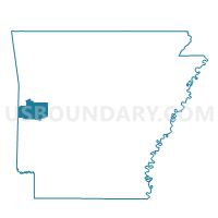
James Voting District, Scott County, Arkansas
About
Outline

Summary
| Unique Area Identifier | 528091 |
| Name | James Voting District |
| County | Scott County |
| State | Arkansas |
| Area (square miles) | 24.68 |
| Land Area (square miles) | 24.65 |
| Water Area (square miles) | 0.03 |
| % of Land Area | 99.87 |
| % of Water Area | 0.13 |
| Latitude of the Internal Point | 34.90888000 |
| Longtitude of the Internal Point | -93.86194390 |
Maps


Graphs
Select a template below for downloading or customizing gragh for James Voting District, Scott County, Arkansas


Neighbors
Neighoring Voting District (by Name) Neighboring Voting District on the Map
- Hunt Voting District, Scott County, AR
- Lafave Voting District, Scott County, AR
- Lamb Voting District, Scott County, AR
- Mount Pleasant Voting District, Scott County, AR
- Parks Voting District, Scott County, AR
- Tate Voting District, Scott County, AR
Top 10 Neighboring County Subdivision (by Population) Neighboring County Subdivision on the Map
- Mount Pleasant township, Scott County, AR (515)
- Lamb township, Scott County, AR (393)
- Parks township, Scott County, AR (184)
- Hunt township, Scott County, AR (181)
- James township, Scott County, AR (143)
- La Fave township, Scott County, AR (110)
- Tate township, Scott County, AR (59)